


File:BlueLine.jpg


Size of this preview: 960 × 664 pixels. Other resolutions: 330 × 228 pixels | 1,280 × 885 pixels | 1,299 × 898 pixels.
Original file (1,299 × 898 pixels, file size: 157 KB, MIME type: image/jpeg)
This is a file from the Wikimedia Commons. Information from its description page there is shown below.
Commons is a freely licensed media file repository. You can help.
Commons is a freely licensed media file repository. You can help.
Summary
| Description |
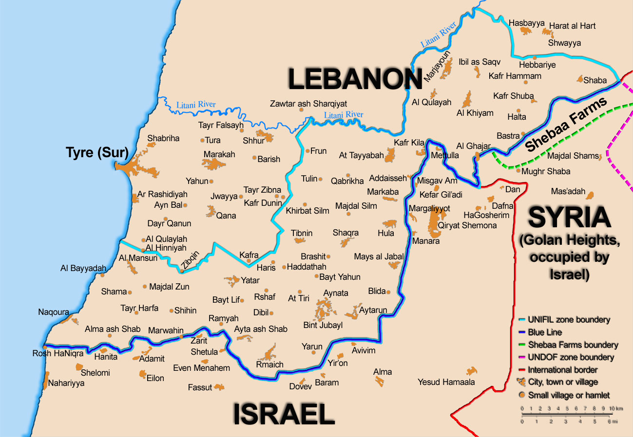
English: Map showing the Blue Line demarcation line between Lebanon and Israel, established by the UN after the Israeli withdrawal from southern Lebanon after its short 1978 invasion called Operation Litani. It follows the 1949 cease-fire line, also known as the Green Line, as well as the somewhat contested Lebanese-Syrian border towards the Israeli-occupied Golan Heights. |
| Date | short 1978 the 1949 July 2006 the 2006 |
| Source | Self-published work by 99of9 |
| Author | 99of9 / * The map is made by Thomas Blomberg using the UNIFIL map, deployment as of July 2006 as source. |
| Other versions |
|


|
This map image could be re-created using vector graphics as a SVG file. This has several advantages; see Commons:Media for cleanup for more information. If a SVG form of this image is available, please upload it and afterwards replace this template with
{{vector version available|new image name}}.It is recommended to name the SVG file “BlueLine.svg”—then the template Vector version available (or Vva) does not need the new image name parameter. |


Licensing
I, the copyright holder of this work, hereby publish it under the following license:


This file is licensed under the Creative Commons Attribution-Share Alike 2.5 Generic license.
- You are free:
- to share – to copy, distribute and transmit the work
- to remix – to adapt the work
- Under the following conditions:
- attribution – You must give appropriate credit, provide a link to the license, and indicate if changes were made. You may do so in any reasonable manner, but not in any way that suggests the licensor endorses you or your use.
- share alike – If you remix, transform, or build upon the material, you must distribute your contributions under the same or compatible license as the original.
File history
Click on a date/time to view the file as it appeared at that time.
| Date/Time | Thumbnail | Dimensions | User | Comment | |
|---|---|---|---|---|---|
| current | 10:44, 16 November 2010 | | 1,299 × 898 (157 KB) | 99of9 | Reverted to version as of 20:09, 21 October 2010. These boundaries appear to be accepted by both "sides" of the war. Their difference is over the label SYRIA (occupied...) over Golan Heights. For that we are now consistent with the original uploader's |
| 20:09, 21 October 2010 |  | 1,299 × 898 (157 KB) | Nableezy | keep boundary changes but restore label for syria | |
| 16:30, 17 August 2006 |  | 1,299 × 898 (238 KB) | Thomas Blomberg | ||
| 14:16, 4 August 2006 |  | 1,299 × 898 (643 KB) | Thomas Blomberg | Map showing the Blue Line demarkation line between Lebanon and Israel, established by the UN after the Israeli withdrawal from southern Lebanon after its short 1978 invasion called "Operation Litani". It follows the 1949 cease-fire line, also known as the |


File usage
The following 26 pages use this file:
- 1978 South Lebanon conflict
- 2010 Israel–Lebanon border clash
- Borders of Israel
- Edward Said
- Hanikra border clash
- History of Hezbollah
- Israeli occupation of Southern Lebanon (1982–2000)
- Israeli–Lebanese conflict
- Lebanese Civil War
- Shebaa Farms
- South Lebanon conflict (1985–2000)
- United Nations Security Council Resolution 1122
- United Nations Security Council Resolution 1525
- United Nations Security Council Resolution 1655
- United Nations Security Council Resolution 425
- United Nations Security Council Resolution 426
- United Nations Security Council Resolution 427
- United Nations Security Council Resolution 434
- United Nations Security Council Resolution 444
- United Nations Security Council Resolution 501
- United Nations Security Council Resolution 511
- United Nations Security Council Resolution 519
- United Nations Security Council Resolution 659
- Talk:List of ongoing armed conflicts
- User:Falcaorib/Israel, Palestine and Jordan
- User:Falcaorib/Syria and Lebanon
Global file usage
The following other wikis use this file:
- Usage on ar.wikipedia.org
- Usage on ast.wikipedia.org
- Usage on azb.wikipedia.org
- Usage on bs.wikipedia.org
- Usage on ca.wikipedia.org
- Operació Litani
- Conflicte Israel-Líban
- Història del Líban
- Resolució 262 del Consell de Seguretat de les Nacions Unides
- Resolució 279 del Consell de Seguretat de les Nacions Unides
- Resolució 313 del Consell de Seguretat de les Nacions Unides
- Resolució 317 del Consell de Seguretat de les Nacions Unides
- Resolució 337 del Consell de Seguretat de les Nacions Unides
- Resolució 427 del Consell de Seguretat de les Nacions Unides
- Resolució 425 del Consell de Seguretat de les Nacions Unides
- Resolució 434 del Consell de Seguretat de les Nacions Unides
- Resolució 444 del Consell de Seguretat de les Nacions Unides
- Resolució 501 del Consell de Seguretat de les Nacions Unides
- Resolució 519 del Consell de Seguretat de les Nacions Unides
- Resolució 659 del Consell de Seguretat de les Nacions Unides
- Resolució 938 del Consell de Seguretat de les Nacions Unides
- Resolució 1122 del Consell de Seguretat de les Nacions Unides
- Resolució 1525 del Consell de Seguretat de les Nacions Unides
- Resolució 1655 del Consell de Seguretat de les Nacions Unides
- Resolució 1697 del Consell de Seguretat de les Nacions Unides
- Resolució 1773 del Consell de Seguretat de les Nacions Unides
- Usage on ckb.wikipedia.org
- بڕیارنامەی ٤٢٦ی ئەنجومەنی ئاسایش
- بڕیارنامەی ٤٢٧ی ئەنجومەنی ئاسایش
- بڕیارنامەی ٤٣٤ی ئەنجومەنی ئاسایش
- بڕیارنامەی ٤٤٤ی ئەنجومەنی ئاسایش
- بڕیارنامەی ٥٠١ی ئەنجومەنی ئاسایش
- بڕیارنامەی ٥١١ی ئەنجومەنی ئاسایش
- بڕیارنامەی ٥١٩ی ئەنجومەنی ئاسایش
- بڕیارنامەی ٦٥٩ی ئەنجومەنی ئاسایش
- بڕیارنامەی ١١٢٢ی ئەنجومەنی ئاسایش
- بڕیارنامەی ١٥٢٥ی ئەنجومەنی ئاسایش
- بڕیارنامەی ١٦٥٥ی ئەنجومەنی ئاسایش
- Usage on cy.wikipedia.org
- Usage on de.wikipedia.org
- Libanonkrieg 2006/Zeittafel
- Blaue Linie (Libanon)
- Diskussion:Libanonkrieg 2006/Archiv 3
- Resolution 659 des UN-Sicherheitsrates
- Krieg in Israel und Gaza seit 2023
- Israelisch-libanesische Beziehungen
- Resolution 434 des UN-Sicherheitsrates
- Resolution 444 des UN-Sicherheitsrates
- Wikipedia:Hauptseite/Archiv/31. August 2025
- Wikipedia:Hauptseite/Archiv/1. September 2025
- Usage on el.wikipedia.org
View more global usage of this file.


